
Enter departure & arrival ports.
Get instant route recommendations.

Distance, ETA, canal & strait transits, special areas, piracy and ECA zones crossed — on real shipping lanes, in seconds.

Free to start · runs in your browser · built on official IMO, WPI & Copernicus data

Whoever you are on the voyage, the questions are the same — and too slow to answer.

Officer of the Watch

Appraisal stage of a passage plan means checking port location, ship's routing publications, sailing directions and old plans — an hour+ gone just to see the distance and initial waypoints.

Master

"Captain, revert immediately distance & ETA if we avoid the Panama Canal?" — the office wants it now, but your navigation officer is still resting.

Shore Ops / Chartering

Every voyage estimate means waiting for the vessel to reply, then when verifying route you have piracy zones in one PDF, ECA limits in another and Additional Premium areas in another monitor. The back and forth communication delays and the pressure to respond is a wasted time and effort for everyone.

What you get

Everything the route needs to tell you.

One search draws the route. Then NaviBoss starts answering questions you haven't asked yet.

Route intelligence

The recommended route, not just a random line on a map.

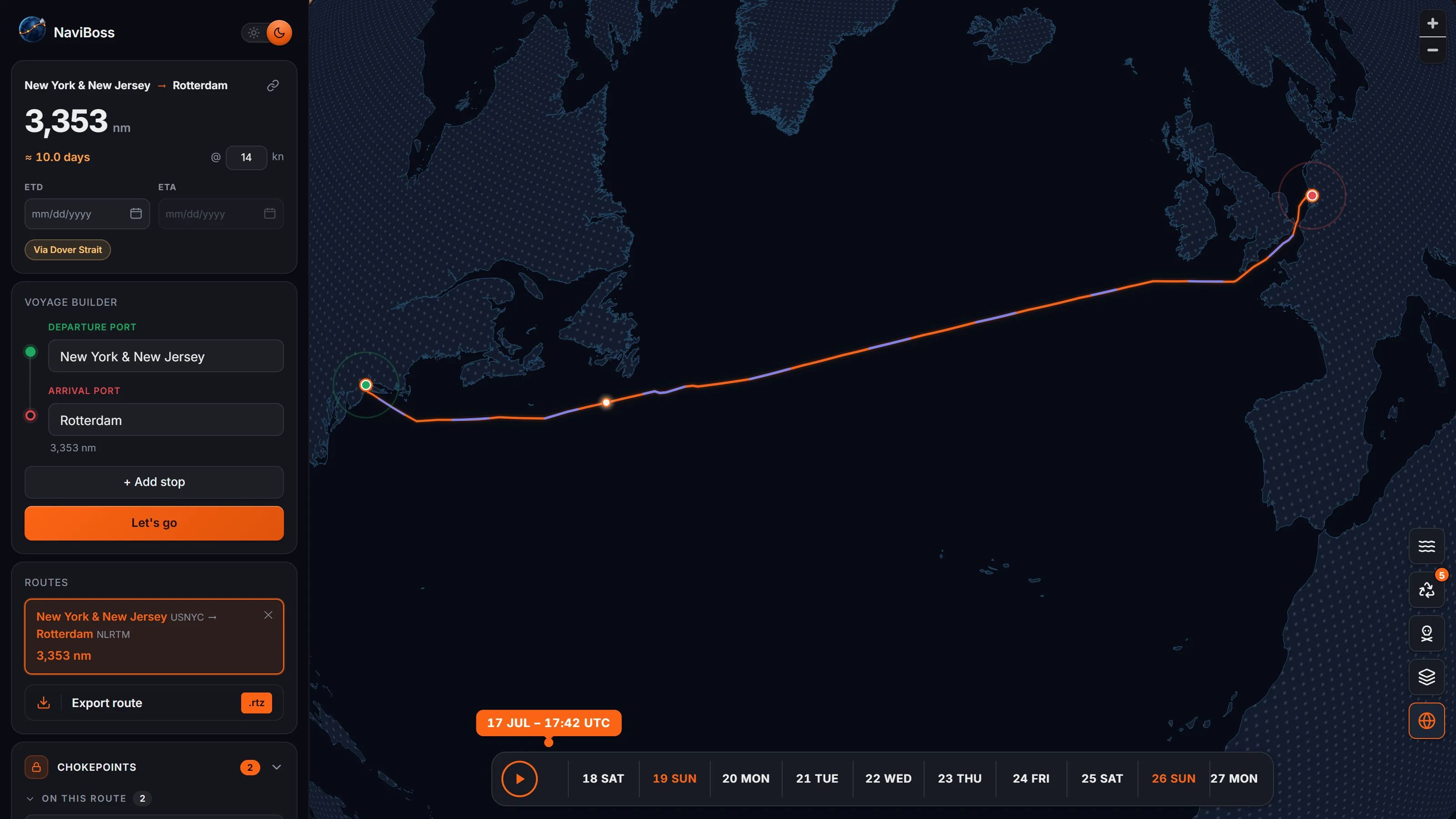
  • Routes follow curated professional shipping lanes
  • Per-leg and total distance in nm, ETA at any speed
  • Drag the track anywhere to add a via-waypoint; the route rebuilds instantly
A recommended route between two ports following real shipping lanes, with per-leg distances in the sidebar
Alternative routes

Don't want Suez or Panama? Block it.

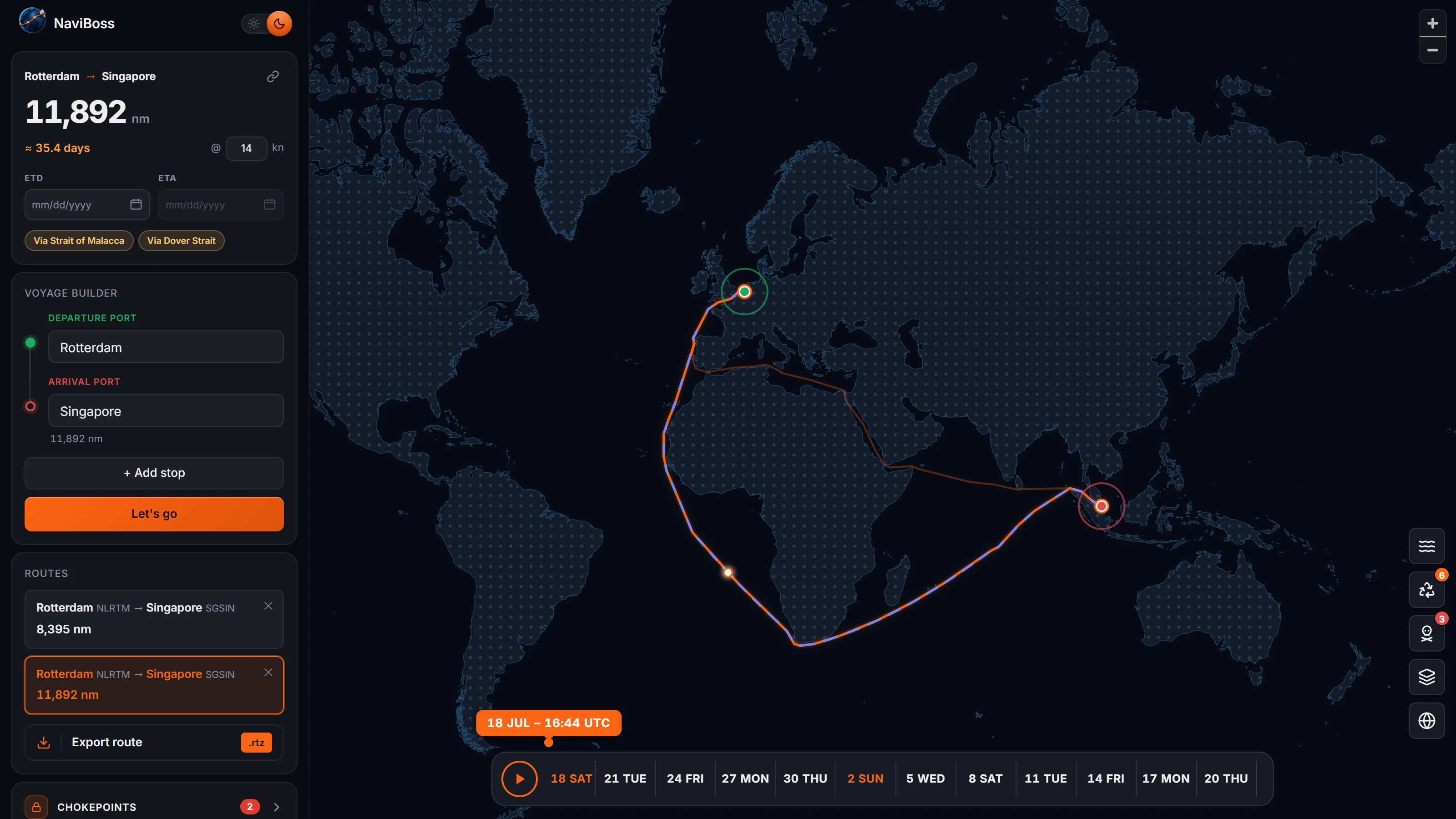
The alternative route appears instantly — with the exact distance difference in nm.

  • 900+ canals & straits, blockable with one tap
  • Hover any chokepoint to preview the reroute as a ghost line
  • Difference of every avoidance shown in nm before you commit
The Suez Canal blocked in NaviBoss: the voyage re-routes around the Cape of Good Hope with the added distance shown
Security & environment

Know every zone before you enter it.

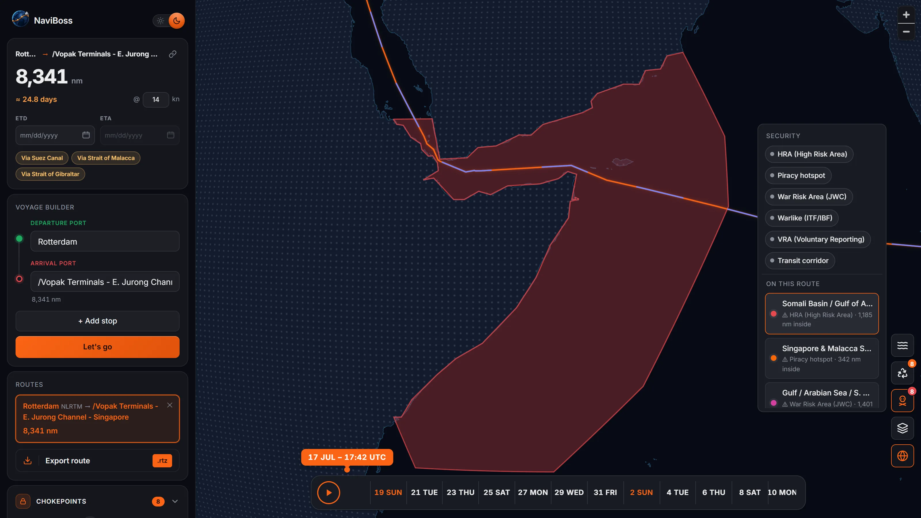
  • Piracy HRAs, war-risk & advisory areas — current industry designations
  • ECAs, MARPOL special areas and PSSAs from official IMO coordinates
  • 58 zones, 9 categories — with the exact miles your route runs inside each
Security and emission-control zones drawn on the chart, with the miles the route runs inside each zone listed
Ocean currents

Currents? One click, and your route rides them.

Minimum-time routing through real monthly current data — with hours saved shown next to the track.

  • Animated overlay — Copernicus GLORYS12 climatology
  • Optimized vs shortest route, both on the chart
  • Gulf Stream, Agulhas, Kuroshio — take advantage of it
The animated ocean-currents overlay with a route optimized to ride favorable currents, showing hours saved
Compare & decide

Compare two or more routes in seconds.

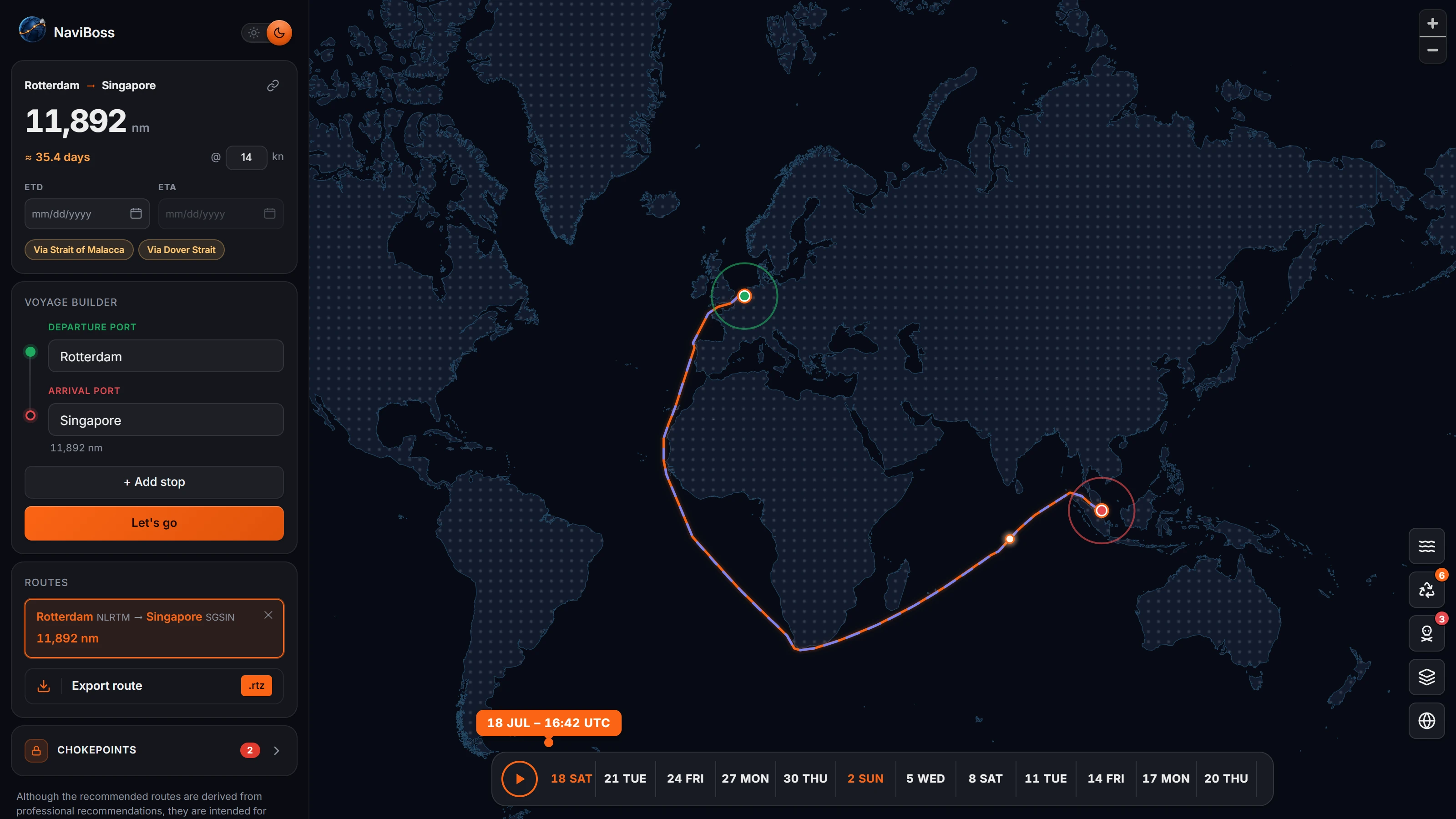
  • Each click freezes a voyage card — route, distance and avoid-set locked in
  • Via-Suez vs via-Cape vs current-optimized, compared at a glance
  • One click restores any scenario exactly as you built it
Two saved voyage scenarios compared side by side, each with its own route, distance and avoided passages
July currents across the North Pacific, animated from Copernicus GLORYS12 — exactly as they render in the planner.
Everything on board

And that's not the half of it.

Fourteen more reasons this replaces the tab pile.

7,000+ ports

Searchable by name or UN/LOCODE.

ETD ⇄ ETA solver

Set the ETA and get the required speed, or set the speed and get the ETA.

Voyage playback

A ship sails your route against a sim clock; scrub to any moment of the passage.

Day/night terminator

Exact sunlight line on the chart; stretches sailed in darkness drawn in indigo.

ECDIS-ready export

Export as RTZ, compatible with most ECDIS.

Share links

One URL restores the whole scenario: ports, avoids, speed, ETD.

3D globe ⇄ flat chart

One click between projections, routes drawn true on both.

Time zones overlay

Maritime zones with a UTC ruler along the chart edge.

Load Line zones

The maritime loadline zones, on the chart where they apply.

Countries overlay

Borders and names when you need the geographical picture.

Live position readout

Lat/lon under your cursor in degrees-minutes, plus coordinate rulers.

Day & night themes

A bridge-friendly dark chart, or a crisp day view.

Runs on ship internet

Fully client-side after one load; no server round-trips to plan.

Offline desktop edition

The full planner with no internet at all.

Three steps. No manual.

  1. 1 Search

    Type your departure and arrival ports — by name or UN/LOCODE.

  2. 2 See

    The recommended route, distance and ETA appear instantly. Adjust speed, block passages, add stops.

  3. 3 Ship it

    Export the RTZ to your ECDIS, or share a link that opens the exact voyage.

One tool. For onboard crew and shore personnel.

At sea — officers & masters
  • Appraisal-stage answers before the coffee cools
  • Second-check a route or ETA independently
  • What-if answers for the office — without losing rest hours
Ashore — ops, chartering & management
  • Voyage estimates while the charterer is still on the line
  • Same numbers across the whole fleet — no more "which spreadsheet?"
  • Nothing to install or license per seat

Choose how you plan your voyage.

Free trial

The full planner, in your browser — 7 days, no sign-up.

  • Instant routing on real lanes
  • Alternative routes
  • Security & ECA zones
  • Currents + optimization
  • Every feature, every port
Start free — no sign-up
Pro

For daily professional use.

  • Everything in Free
  • Saved voyages
  • Priority data updates
Let's go
Fleet

For companies.

  • Multi-seat
  • Shared voyage library
  • Onboarding & support
Talk to us

Pricing is being finalized — early users lock in launch discounts.

Fair questions.

Where do the routes and data come from?

Routing follows a curated network of professional recommended shipping lanes. Ports come from the World Port Index plus terminal data. Security and environmental zones are built from official IMO instruments (MARPOL Annex VI ECAs, special areas, PSSAs) and current industry HRA designations. Currents are Copernicus GLORYS12 ocean-model climatology.

Will my ECDIS accept the export?

Yes — NaviBoss exports RTZ 1.0 route plans per IEC 61174, matched to files ECDIS are known to accept. Load the file and your waypoints are inside ECDIS.

Is this approved for navigation?

No. NaviBoss is a passage-planning and voyage-estimation aid. Routes derive from professional recommendations, but they're for informational purposes only and must never replace official charts, publications or your own navigation.

Does it work on slow ship internet — or offline?

Yes, a fully offline desktop edition is designed for seafarers onboard with limited internet access.

What does it cost?

The online planner is free for 7 days — every feature, no sign-up. Pro, Fleet and the offline desktop licenses (annual & lifetime) are coming — see Pricing above and join the waitlist for launch discounts.

Instant voyage planner that works fast

Everything you just saw, one search away.

Plan a Run in browser or use offline